Criteria
Expo Line Light Rail Phase 1 Phase 2 Criteria Neighbors
|
Criteria |
| Home
News Contact
Links Support
Flier (pdf)
Discussion Expo Line Light Rail Phase 1 Phase 2 Criteria Neighbors |
|
|
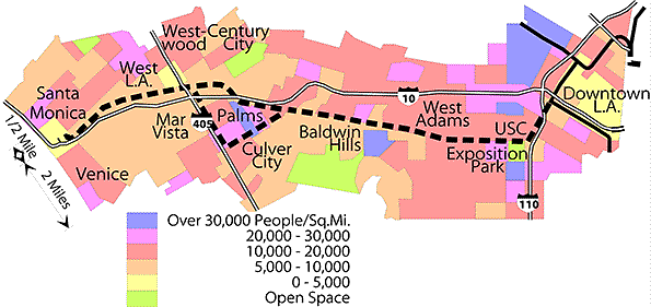
Exposition Population
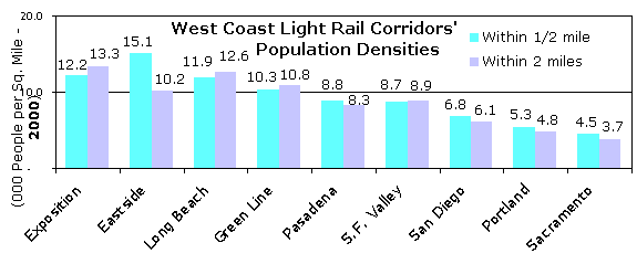
The population within two miles would be the 12th-largest city in the United States! Particularly high-density neighborhoods include downtown, Baldwin Hills, Palms, West L.A., and Santa Monica. Light Rail Corridors
Source: U.S. Census 2000 tract populations from P.L. 94-171 Counts (Updated 4/7/01) Capacity
|
|
Speed and CostThe "bus rapid transit" alternative for phase 2 would be slower and have lower capacity than the light rail extension this corridor requires. The Expo Line is projected to carry over 50,000 daily riders. To match the planned capacity of a 3-car train every 5-6 minutes would require a bus a minute in each direction—a bus every 30 seconds. Light rail would take 35-45 minutes from 4th Street, Santa Monica to 7th Street, downtown Los Angeles. A busway built to the standard of light rail, with a number of grade-separations, would cost nearly as much as light rail, but still be slowed by remaining intersection signals and the transfer in Culver City. An at-grade busway like the Valley's Orange Line would be even worse, with buses slowing or stopping at all intersections. (updated 4/8/09) Home Top < Back - Phase 2 construction Next - Neighbors >
|